Dining
- + Is there anywhere to eat if we camp in Hartsburg? Looks like nothing until tebbetts? Breakfast options?
Discussion started 01/31/2024 01:10 PM by Jodie - 3 replies (last reply by Hiking America at 02/01/2024 09:47 AM)Jodie from St Louis on 01/31/2024 01:10 PM
Is there anywhere to eat if we camp in Hartsburg? Looks like nothing until tebbetts? Breakfast options?
Gary from Near Tebbetts on 01/31/2024 01:39 PM
There is Jefferson City, half way between Hartsburg and Tebbetts. Tons of food options, bars and places to spend the night, plus you get to experience the bike/pedestrian bridge crossing the Missouri River.
Jim from St. Thomas on 01/31/2024 03:49 PM
There is no place to get food in Tebbetts unless you contact Rachel at Happy Trails Katy-ring ahead of time. She and her girls provide an excellent breakfast.
https://bikekatytrail.com/happy-trails-katy-ring.aspx
If you want to eat in JC but don’t want to do the extra miles to cross the bridge to get downtown, you can get a good breakfast at the Landing Zone located at JC’s small airport every day except Wednesday.
https://landingzonemo.com/
Hiking America on 02/01/2024 09:47 AM
Two places to eat in Hartsburg, but none for breakfast off-season.
There's the Hartsburg Hitching Post - M-Th 4p-Mid, F-Sa 3p-1a, Su 12-Mid
"The Burg" is only open on Friday and Sat nights during the off-season And Thurs-Sun in season.
In-season, The Berg serves breakfast on Saturday and Sunday mornings.
 post to Facebook
or share this link to just this thread:
Dining
https://bikekatytrail.com/talk.aspx?tid=13743&tonly=1
Country Inn & Suites On Historic Main Street in St Charles
- + We are planning to drive . . Is there a shuttle from here to Rock island trail ? Also is there a safe place to leave my car?
Discussion started 01/10/2024 12:10 PM by Wanderer - 2 replies (last reply by Eric at 01/27/2024 12:55 PM)Wanderer from Kings Mtn on 01/10/2024 12:10 PM
We are planning to drive . . Is there a shuttle from here to Rock island trail ? Also is there a safe place to leave my car?
SCOTT from OKC on 01/26/2024 02:08 PM
Call the Bike Stop Cafe in St. Charles, they provide shuttle services.
We stayed at the Country Inn and Suites, great hotel. Short walk to the BSC.
Eric from KCMO on 01/27/2024 12:55 PM
Key security idea: Some of you have discussed or considered parking your vehicle and shuttling back to it with your bike versus having a company drive YOUR vehicle to the opposite end of the trail where it will wait for you upon arrival/completing the trial. In 2021 I rode the Katy but began in Kansas, rode all the way to Illinois and back into Missouri, finishing at Gateway Arch and Busch Stadium. I took the Amtrak back to KC, so moving a car wasn’t an issue. A few months ago I rode the awesome Mickelson Trail in South Dakota. I only had a few days to ride and didn’t have a support person to pick me up. I considered using a shuttle, but decided I wanted to hire Black Hills Discovery Tours to drive my truck to Edgemont, at the other end of the trail. This is more expensive than the shuttle for a solo rider but would cost about the same as two riders, plus I don’t have to ride the shuttle that two hours back. Remember when considering the cost whether it’s the Katy or the Mick it takes two people to shuttle a vehicle because the driver needs a ride back. Back to key security….i was uneasy about my keys being left hidden in my truck for a day, or longer. I purchased a real estate type key box from amazon for $20. Originally I was going to return it and get my money back but decided to keep it for future trips or if I have someone coming to my house to leave a key. This box has a combination that can be set easily to whatever four digit code I want. To make it easy for Bill at Black Hills Discovery Tours I set the code to the last four digits of his phone number. I then locked the key box to the tie down hook in the bed of my truck, but if you have a hitch receiver or roof rack it could go there, maybe even to a door handle…you get the idea. The box is pretty rugged and would take time, tools and effort to force entry into. Obviously there is some risk of theft with keys inside the box, however people/thugs steal cars by breaking in then damaging the steering column or ignition all the time without keys available.
https://www.amazon.com/Capacity-Storage-Resettable-Combination-Waterproof/dp/B09NBQW6D2
Which way is best, St Charles to Clinton or reverse ?
- + Just wondering if people had a preference for starting and ending ponts.
Discussion started 01/23/2024 08:15 AM by Will - 13 replies (last reply by CurtM at 01/26/2024 02:54 PM)Will from Lake Ontario on 01/23/2024 08:15 AM
Just wondering if people had a preference for starting and ending ponts.
Kerry H from Tucson AZ on 01/23/2024 10:16 AM
Hi! We are going to KT in May and according to some friends they said to go West to East. We are starting in Clinton, which is a small town but I had little trouble getting a room.
There is (apparently) a city parking lot that is free so you could park there and go to St. Charles and then shuttle back. The shuttle is $110 a person and goes daily from STC to Clinton at 0800.
If you decide to go to Manchens, then that's a 30 mile round trip to get back to STC.
Of course you could cycle back.
Anonymous on 01/24/2024 06:57 AM
The trail is downhill going west to east. Maybe not all that much beings it is a rail trail, but the hill in Boonville wasn’t named Lard Hill for nothing. The elevation chart at the bottom of the mileage chart shows the elevation of each town along the trail. Best—downhill.
Wind direction changes often and it can swirl along the bluffs making the headwind/tailwind debate kind of a moot point to me. Best—either direction.
Which way is best? Based on what? Slope of trail…wind direction….travel plans before and after riding….required amenities before and after the ride…time of day riding into the sun or on your back….etc? Best—depends on you.
Bill R. from Wentzville on 01/24/2024 08:23 AM
I rode the whole trail last summer. West to east is a bit easier, especially the western most part of the trail. Like was said before, Boonville offers a lot of exercise going east to west. It's not a "hill" but rather a slight "grade". Grade equals no coasting for maybe a mile or better. Sedalia to Clifton City was pretty gravelly. I was really glad my tires and tubes were new when I did that stretch. Otherwise it might have been pretty iffy. Enjoy.
Will from Lake Ontario on 01/24/2024 09:35 AM
Thanks for the info, I really appreciate that. Does anyone have the name and number for the shuttle service from St. Charles to Clinton?
Alan from Sedalia on 01/24/2024 10:34 AM
There's only about 500 feet of elevation difference from the high point to the low point so the trail is pretty flat. The only other physical reason for choosing one direction over the other is the wind. Some people will argue it doesn't matter because the wind changes so much and geography affects it too much, etc. However I've ridden sections of the trail a lot and I did a round trip of the entire trail last year and yes wind direction will vary but from my personal experience most of the time it's easier going west to east.
Jerry Whittle from O'Fallon Illinois on 01/24/2024 01:48 PM
I've done the entire trail 11 times with about half each direction. I prefer west to east as the tailwind is 'usually' that way. Plus there is that nice downhill into Boonville. However there are two downsides going that direction.
1. If you are an early riser, the sun will often be in your eyes.
2. Some businesses, such as restaurants, are closed on Mondays and Tuesdays in the smaller towns. However this issue can be avoided by starting in Clinton on Monday then spending the night in Sedalia. On Tuesday spend the night in Boonville.
Anonymous on 01/25/2024 01:54 PM
"There's only about 500 feet of elevation difference from the high point to the low point so the trail is pretty flat."
That's over roughly 200 miles....so yes it's pretty flat.
But from Boonville to Pilot Grove the elevation gain is 220 feet.
From Boonville to Sedalia the elevation gain is 290 feet.
It's pretty flat from Kansas City to Salt Lake City too...except that part where ya have to go over the Rocky's.
Cathy from Churchill from Churchill, PA on 01/25/2024 11:38 PM
Oh Anonymous, you're such a party pooper.
I did a ride from Rocheport to St. Charles and I don't recall elevation or wind being an issue. I do believe the elevation challenge is probably west of Rocheport.
I've ridden a lot between Huntsdale and Rhineland and the wind is catch as catch can.
Gary from Near Tebbetts on 01/26/2024 12:02 AM
Some people prefer to get those long stretches of slight inclines in the west part out of the way early when their legs are fresh than to do them when coming at the end of the ride after you have ridden the relatively flat east part of the trail.
Anonymous on 01/26/2024 09:55 AM
Yep....reality can be a party pooper. Or it at least can make a bike ride less enjoyable than it could have been.
That's what really makes Gary's post relevant.
Alan from Sedalia on 01/26/2024 10:24 AM
Of course there are some hills. It's Missouri after all. Between Sedalia and Booneville there are a few that go on for what seems like a mile but they are a very slight gradient. Overall the trail is pretty flat and pretty easy, even with a loaded down bike.
SCOTT from OKC on 01/26/2024 02:00 PM
My preference is also W to E. And driving from OKC to Clinton is about 5 hours. So instead of trying to camp or hotel in Clinton, we choose to roll the easy 17 miles to Winsor and stay and Katy Rock Junction! It a great place with little "home depot" type shed cabins. RIGHT off the trail on the left, just past the Star Spangled Caboose, which will be on the right. There's a Casey's right there too and several nice small town eateries in Winsor. This way you can make your trek from your home town and still get a few miles on the first day.
**Take WARNING though... The Clinton Community Ctr will not let you leave your car keys for the Bike Stop Cafe transport. The first time I rode the KT with my adult sons in Oct '22, we were able to fill out a form and they took my keys and the form. The BSC came and got my truck and it was waiting for us at our hotel in St. Charles. This past Oct when hitting the trial with my wife, the lady at the Comm Ctr said - "we don't do that, never have". Well I must have imagined that then. But i didn't. She said you can leave your car here, fill out his form, it can stay here for up to a week before we have it towed. She was surely NOT the friendliest person in Clinton. I called the BSC and they had their transport driver, Tony, meet us along the trail at Green Ridge, on our second day.
Scotty Mac - OKC
CurtM from Farmington AR on 01/26/2024 02:54 PM
Just another 2 cents worth. I've been on four trips on the MKT, either all or parts, and direction doesn't make much difference, although going west to east with the downhill into Boonville preferable. I've never been on the trail when the winds were favorable; more often than not, there was no wind or there was a headwind. It is more important where you overnight, as you will be at your best in the AM. A great option, which eliminates a shuttle, is to head west from Clinton to St Charles. The out and back to and from Machens is an easy 24 miles round trip, so you can do the entire trail. Then double back from STC to either Washington or Hermann, and catch the train back to Sedalia. Then ride from Sedalia to Clinton. You bypass all the grades around Boonville, and the trail from Sedalia to Clinton (east to west) is really pleasant. You do need to be flexible, as you have to be in place to meet the train, and it doesn't always keep on schedule. Also, it adds some time to the trip. It's more complicated than I can explain in a comment, as there are many options for waypoints and overnight locations, but with some research a rewarding itinerary is possible.
Questions: Machens, Illinois
- + Hello! I’m planning to ride round trip the entire Katy Trail this April and starting from Machens. Questions...
Is the entire trail open? I see that person on the blog from KC said it was closed in M...
Discussion started 01/21/2024 09:25 AM by RB - 7 replies (last reply by Raff at 01/22/2024 07:06 PM)RB on 01/21/2024 09:25 AM
Hello! I’m planning to ride round trip the entire Katy Trail this April and starting from Machens. Questions...
Is the entire trail open? I see that person on the blog from KC said it was closed in Machens.
Also do you know of a place in Illinois along the Mississippi River that would connect to the Katy trail to start from?
Thanks for your help. I’m sure I’ll have more questions as it gets close. Any tips would be appreciated.
Jerry Whittle from O'Fallon Illinois on 01/21/2024 10:16 AM
Machens is not the ideal place to start especially if you are parking a car. Your best bet is to do a 24-miles out and back from St. Charles to start. The trail ends in Machens. It was closed near Machens a few years ago due to flood damage, but it's been fixed for a while.
You can start over in Alton, Illinois. The Hwy 67 bridge over the Mississippi River has a bike path, but there is often a lot of broken glass on it. However the bike path ends shortly after the bridge. The shoulder of Hwy 67 is wide. You'll need to turn right onto Hwy 94 and stay on it for a few miles. It usually isn't all that busy. If you are looking at something like Google Maps, there seems to be side roads, but many of them are rough dirt. Interesting factiod: RAAM (Race Across AMerica) uses Hwy 67 and the bridge.
Another option from Illinois is from Grafton. Take the Grafton Ferry over the Mississippi River. Note: Do NOT take the Brussels or Golden Eagle ferries. Make sure that the Grafton ferry is open as river conditions often close it.
DS Douin from KT most likely on 01/21/2024 11:18 AM
I agree with Jerry. Starting from Machens is not a good idea especially in April. If you want to say you did the entire KT Trail wait until summer and park in St Charles and do an out an back to Machens. Trail east of St Charles is not real developed. Start from or end in St Charles would be a good first KT trip. Riding from Illinois to start would be in the summer time.
Raff from Elk Grove Village, Illinois on 01/22/2024 08:05 AM
Ok wow thanks for the tips. I’ll look at all those tips and plan it better. Yeah parking the car is scaring me. Maybe park at a hotel or township building in St. Charles or Alton, Grafton? But there’s nothing to worry about being on the trail? Safe?
Alan from Sedalia on 01/22/2024 09:59 AM
I did a round trip of the Katy last September. I was riding alone and camped by myself most nights. I never once felt unsafe at any time. You will go through a few areas that look a bit sketchy and you will see homeless people occasionally but I never had any trouble.
Jerry Whittle from O'Fallon Illinois on 01/22/2024 10:00 AM
I recommend parking in St. Charles. There's a public park there where I've left my car 5 or 6 times. I just left a little note on the dashboard giving the phone number and email address where I can be reached. Flooding could be an issue, but then you don't want to be riding on the Katy when the Missouri River is up that high anyway.
As mentioned before, start at St. Charles and do an out and back to Machens. That way you can claim rights to doing the entire Katy.
The trail is very safe. Just be careful at intersections with the road. There's one place near St. Charles and another near Augusta where it's difficult to see the road traffic. Just be careful.
Eric from KCMO on 01/22/2024 10:30 AM
Raff: the issues with Machens primarily are related to access to/from the trail. There is a legal right of way to/from the trail from the local roads/highway. That access allows you to legally get to the trail, including crossing an active rail line. The owner of the property adjacent to and surrounding the Katy/state park is not a supporter of the trail and has been known to place barriers to keep people out. There is no designated parking at the Machens trailhead and because property lines are not clearly marked one could “accidentally” trespass. Interesting fact about the property owner is his name is Machens. I believe that most trail users are simply using the trail for its intended purpose and not committing crimes. Another issue with Machens and all areas east of St Charles is that it’s not as scenic in some people’s opinions (I’ve seen quite a few comments related to that over a few years) so that’s why some may believe it’s not worth doing. I don’t feel that way, just understand it’s flat river bottom farmland far enough away from both rivers that you don’t see them. I enjoyed that section and would regret missing it and the bell at the end.
Regarding safety, most people overwhelmingly have a safe trail experience. Some may see someone or something that they don’t like, but that could be their own insecurities or prejudice, but even then typically nothing happens to them. Unfortunately cars sometimes get broken into, so park somewhere that seems safe. Also don’t leave anything of value visible inside your car, including change or bags….what you think is a bag of dirty laundry might appear to be a bag with POTENTIAL valuables to a thief.
I rode from Westwood, KS to Alton, IL crossing the Mississippi via the Grafton Ferry. I then rode across the bike/pedestrian only Old Chain of Rocks Bridge ending at Gateway Arch. I will include a link below to my Strava for the specific route. There is currently one closure at Mokane for a bridge replacement until March. I suggest going to Mo state parks website and use the trail advisor link on that site for official info. Sometimes you can get around those closures, but it may not be an authorized detour. I suggest Facebook group Fans of the Katy Trail for a greater audience and media than this good resource here.
https://strava.app.link/6N4dLH1tzGb
Raff from Elk Grove Village on 01/22/2024 07:06 PM
Thank you Eric, Jerry and Alan and everyone else. I appreciate all the kind help and advice. I’ll do my best with my ride and I’ll let you guys know when I plan for sure when I leave. I did a solo bike packing trip from Elk Grove Village to Lacrosse, Wisconsin and back. Well almost lol. It was for sure a great peaceful experience and I hope for the same on this trip.
Cheers
Amtrak Pilot Program - Adding A Dedicated Car For Bikes
- + 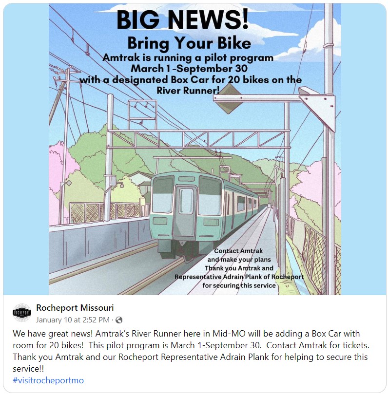 Webmaster's note: the Facebook link that Jim posted stopped working, so I replaced it with the actual content that...
Discussion started 01/10/2024 04:04 PM by Jim - 2 replies (last reply by Deby at 01/11/2024 06:56 AM)Jim from St. Thomas on 01/10/2024 04:04 PM
Webmaster's note: the Facebook link that Jim posted stopped working, so I replaced it with the actual content that you see above (was at https://www.facebook.com/groups/499221650808158/
permalink/1459606934769620/)
This is excellent news!
Anonymous on 01/10/2024 06:43 PM
This group is private
Join this group to view or participate in discussions.
Deby from Dallas Tx on 01/11/2024 06:56 AM
Oh My Gosh, did this headline ever get my attention. Is there a group soliciting Amtrak to help us trail riders??? We love the Katy, and it would be extremely helpful if we had more options to use Amtrak by the ability to load more bikes. There is no doubt more folks would be taking Amtrak if they could get their bikes onboard. It is such a great experience, but so limited right now.
KT General Questions
- + 1. I ride a bachetta ti recumbent. Tires are 23s. Is the trail hard packed for this type of bike and riding?
2. Hoping to ride in May. Possibly mid May. Generally how is the weather and flooding is...
Discussion started 01/08/2024 12:25 PM by Demetrius J Karos - 7 replies (last reply by wroundey at 01/10/2024 03:06 PM)Demetrius J Karos from La Grange IL on 01/08/2024 12:25 PM
1. I ride a bachetta ti recumbent. Tires are 23s. Is the trail hard packed for this type of bike and riding?
2. Hoping to ride in May. Possibly mid May. Generally how is the weather and flooding issues?
3. We are coming from the Chicago area. Where would you recommend parking and start riding. Plan to park and ride 1-2 days out and back.
Gary from Near Tebbetts on 01/08/2024 10:45 PM
I consulted my magic 8 ball on the possibility of good weather on the Katy mid May and it came back it would be good weather “without a doubt”. So there you have it, the magic 8 ball would not lie. :-)
Bruce Laubach from Williamsburg, Virginia on 01/09/2024 06:59 AM
I rode the Katy in mid-May, I had a few days of rain, temps in the 40s at night pleasantly cool for the days. water may not be available at all trail heads. It was during the Hight of COVID so I had to carry my own food because not all the eatery's were open.
Anonymous on 01/09/2024 09:34 AM
Most of the trail has hard packed lanes.....one for each direction. Generally most of the trail is hard packed, but it can vary from location to location. Some areas have had large tire eating cracks. As always just watch where your going, no different than trash along a road shoulder. Trail maintenance may force loose chat, etc. It is doable on thin tired bikes though.
The weather in May is controlled by the Magic 8 ball. Closer to time for your ride would be a good gauge for the possibility of rain, flooding, etc. Riding is doable in May though.
We have left our vehicle for out and backs at several trailheads without issue....Sedalia, Rocheport, Hartsburg, Tebbetts, and Augusta. Times change but the North Jefferson trailhead has gotten a bad rap in the past. For that I've moved on to Hartsburg and played it safe.
Jerry Whittle from O'Fallon Illinois on 01/09/2024 09:40 AM
1. The trail is pretty well packed near larger towns such as St. Charles and Columbia. However 23's are too thin for my liking on the Katy. I've ridden around St. Charles and Hermann on 25s and didn't like it. Away from the larger towns the trail can be loose and slippery especially in the rain.
2. If it's going to flood, it's in May and June. It can rain a lot in May.
3. With those thin tires, I'd recommend starting in St. Charles and riding out to Hermann. You could even throw in a 25-mile total out-and-back to Machens from St. Charles.
Alan from Sedalia on 01/09/2024 11:55 AM
I've seen people riding the Katy on recumbent's several times and all seemed to be doing fine. I would want wider tires than 23's but I've seen people doing it on road tires. Most of the trail is pretty smooth and hard packed but there are rocky sections. You may encounter spots where work has been done recently and is soft. The trail is well maintained but there's always the chance especially in the spring of heavy rains and thunderstorms leaving washouts and downed tree limbs on the trail.
David A from Alameda, CA on 01/09/2024 08:18 PM
Rode the Katy RT last May w/my brother & had mostly good weather w/a few days of rain in 12 days. Will take that every time!Trail remained solid even in the rain, but I'm a one-timer. Locals on this forum like Gary or Doug in Bluffton would be great resources for anything Katy. Doug I know is an ex extreme cyclist & could take a good stab at your questions. A stay at his Bluffton Barn & an evening with him is a hoot, & I think many would agree!
wroundey from Mexico, MO on 01/10/2024 03:06 PM
I used to live in St Charles and rode the trail on recumbents all the time. both my singles and my tandem recumbent with my wife. I have ridden with 25s, but most of my bikes have 35-40s and I rarely have issues. Always need to watch out for loose sand/gravel which can pop up randomly. My wife and I plan to ride the entire trail on the tandem recumbent, pulling a trailer, this summer - exact date to be determined based on weather.